The first eight months of the Ostia Forum Project’s graduate programme have certainly not been the easiest, as the Covid-19 pandemic has shut down one and a half of our two planned fieldwork campaigns in Ostia. The circumstances even prevented us from getting access to the ceramic finds kept in the Deposito of Ostia antica whatsoever. Nevertheless, new insights into the already documented material and the complex stratigraphy of the area TFR2 (Taberna Forum Rooms) could be gained during the last couple of months. This has resulted into a new layout of my PhD-project and Trine Bak Pedersen’s PhD- project (Theme 4: Sacrifices and Ritual Deposits). The focus of my dissertation shifted to analysing the entire development of the area TFR2. It is the aim to reconstruct its history with the help of Prof. Dr. Axel Gering’s newest results regarding the building history of the area north-east of the main forum1 and the results of the analysis of the complex stratigraphy of the area TFR2 with a focus on its massive amount of ceramic finds.
Before the Hadrianic building programme changed the whole appearance of the forum and the area around it, the TFR area belonged to a so far undiscovered sanctuary (see fig. 1). In the course of the Hadrianic building programme, the sanctuary was given up and torn down. In its place, the north-eastern Forum portico ‘Main Forum East’ (MFE) and the Taberna complex ‘Taberna Forum Rooms’ (TFR) were erected.
Needless to say, the earliest and the latest phases of the area are of great interest to us: When was the sanctuary founded? Has the area east of the forum always been used as a sanctuary? In which period were the earliest structures built? And when exactly were the sacred structures given up and the area reused as a taberna complex? Other key questions concern the development of the sanctuary and its structures, as it is obvious that not only the temples but also the associated altars had several building phases. These questions can be answered to some extend by analysing the remaining podium structures of the temple and its phases. Some are still visible today, as they have not been torn down completely and were integrated in the backwalls of the MFE portico, while others are noticeable in excavation photos of the early 20th century. With the help of geophysics, it is possible to get a general idea of the different building phases of the temples. In the following months, a thorough analysis of the excavation diaries from 1913 should shed more light on the stratigraphy around the temples.
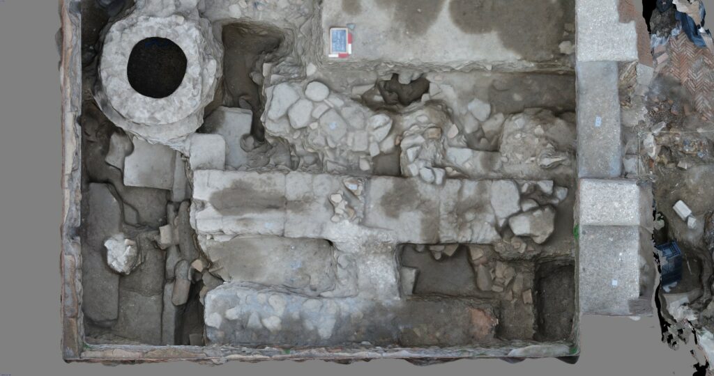
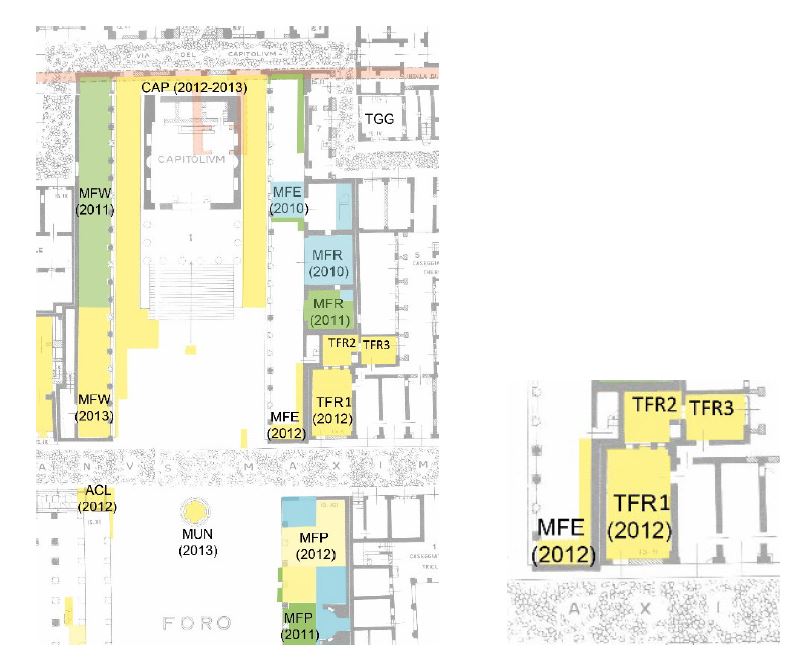
East of the portico, the Taberna complex TFR was partly excavated by the OFP team (see fig. 2). The room TFR2 was explored up until its deepest layers, revealing multiple drains belonging to several altar phases. Only a small trench near the threshold of TFR3 was excavated and the digging activities in the room TFR1 remained mainly in late antique strata. In order to answer the abovementioned questions, the focus consequently lies on the trench TFR2. As this area is not directly connected to the Vulcan temple itself but more so to its altar, interpretations regarding the building phases of the temple must be approached with caution. In addition, the stratigraphy in the area TFR2 is extremely complex, so that proposing a chronology even around the area of the altar is a complicated task.
Gering)
Issues concerning the stratigraphy of the area TFR2
As a fast-growing city dealing with frequent Tiber floods, the accumulation of material and soil in Ostia’s centre was enormous. Especially in an area around an altar, a lot of rubbish must have had collected in relatively short amount of time. It is thus logical, that pavements and corresponding layers have been removed from time to time, especially as the podium of the oldest temple has been reused for its successor temples, resulting in the need to prevent the walking level within the sanctuary from rising endlessly.
Before a new pavement or any other flooring is laid out, the ground below it must be levelled and prepared. In the area TFR2, this is achieved with the help of a layer of soil, mortar, crushed ceramics and a mortar layer or beaten earth on top. When a new building project was initiated (in our area TFR f. ex. a new altar), sometimes the old floor and its bedding have been removed before laying out a new pavement. This explains phenomena like the difference in dating of the layers TFR2 002a and 003b. The layers are only separated by the layer TFR2 003a which is max. 13 cm thick and still, there are at least 150 years between their respective creation. TFR2 003b has most probably been created as a floor preparation layer around the middle of the 1st c BCE, while TFR2 002a, the preparation for the Hadrianic taberna floor, has been created after 130 CE. This stratigraphic situation could for example be explained by pavements, floor preparation and mortar layers from the > 150 years in between the creation of TFR2 002a and TFR2 003b being removed at some point. Of course, such phenomena render it extremely difficult to treat layers in this area as a fine stratigraphy dating specific building phases. It is not quite clear if several layers of old flooring were removed at once when the Hadrianic taberna complex was built or if it was a continuous process of raising and lowering of the levels. On the other hand, we could also be dealing with a beaten-earth floor which was used and repaired for an extended period.
A look at the stratigraphy in the Domus di Giove e Ganimede, which is situated north of the forum, also supports my assumption of either pavements being either removed or used for extremely long periods of time in the area TFR (see Tab. 1).
| Giove e Ganimede: Height ASL | Giove e Ganimede: Date | Giove e Ganimede: Context | TFR2: Height ASL | TFR2: Date | TFR2: Context | |
| 3,30 m | 128–138 CE | Wall foundations for the insula | 2,43 m | post 130 CE | Opus spicatum floor in TFR1 Beaten-earth floor in TFR2 | |
| 2,56 m | 120–130 CE | Threshold destroyed in fire | 2,07 m | Post 119–121 CE / pre 130 CE (brick stamps) | Beaten-earth floor | |
| 1,89 m | Late 1st c – early 2nd c CE | Mosaic floor | 1,96 m | After the middle of 1st c BCE – 119–121 CE (coins) | Repair of beaten-earth floor | |
| 1,35 m | Augustan | Beaten-earth floor | 1,87–1,90 m | Mid-1st c BCE | Beaten-earth floor | |
| 0,64 m | Late 2nd c – 1st c BCE | Floor pavement | 1,70–1,75 m | 2nd half of 2nd c – mid-1st c BCE | Tuff pavement | |
| 1,54–1,60 m | Beginning of 2nd c – 1st half of 2nd c BCE | Tile pavement | ||||
| 1,30 m | End of 3rd c BCE | Tile pavement | ||||
| -0,30 m | Late 4th c – early 3rd c BCE | Sand layer, possibly natural | 1,14 m | Middle – end of 3rd c BCE | Beaten-earth floor |
Tab. 1. Levels in the Domus di Giove e Ganimede (DeLaine – Wilkison, The House of Jove and Ganimede (1999) compared to the levels in the area TFR2
In the Domus di Giove e Ganimede, there is a difference in elevation of 1,95 m – 2,66 m between the late Republican to Augustan levels and the foundations of the insula walls (128 – 138 AD). Between TFR2 003b and 002a (middle of 1st c BCE – 2nd quarter of 2nd c CE) are only 14 cm of soil (TFR2 003a), proving the constant removal of layers in the sacred area. As mentioned above, this phenomenon is certainly caused by the need to keep the walking level from raising indefinitely because of the permanent reuse of the old temple podium.
It also becomes apparent, that the initial rising of the levels in Republican times was not differing as much as in the Imperial strata. In the Domus di Giove a Ganimede, there is a difference of 0,94 m in between the lowest sand layer from the late 4th – early 3rd c BCE and the late Republican layer, in the area TFR2 it is 0,83 m in between those levels. Only after the late Republican period, the development seems to diverge drastically. Below the late Republican layer TFR2 003b, at least two different pavement levels are preserved, above 003b, all floorings have seemingly been removed at some point to avoid the walking level from continuing to rise.
This phenomenon shows explicitly how differently the area within the sanctuary has been treated compared to a residential complex close by. The walking levels of the Domus di Giove e Ganimede and its underlying structures did not react to a relatively fixed walking level determined by a specific building, like the area around the temple did. Reusing the podium of the first temple for its successors created the necessity of the walking level in the sanctuary to always correspond with that structure.
Similar phenomena are documented in other Ostian sanctuaries, such as the Cybele sanctuary and the Hercules temple. In these two cases, it even seems as if the sanctuaries’ levels were lower than the street level after a general raising of the levels in Ostia in the 1st c AD.2
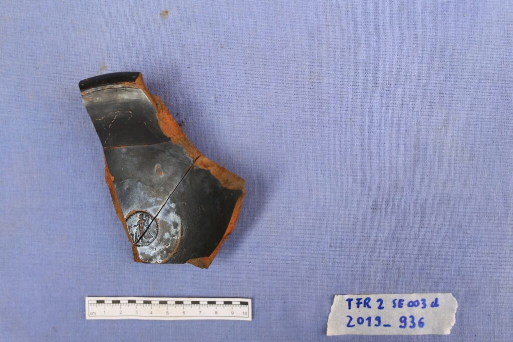
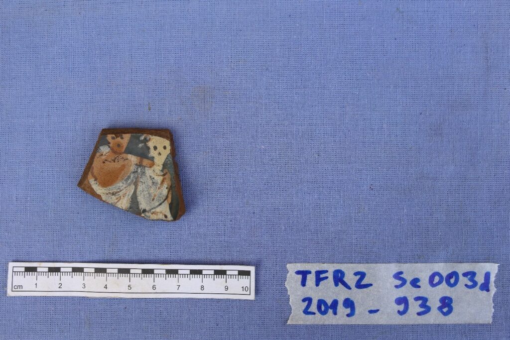
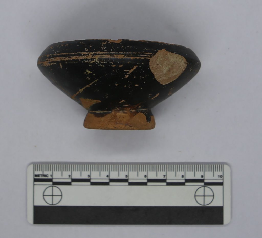
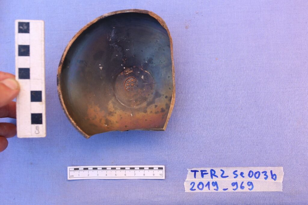
The comparison of the absolute heights of the two sites also illustrates another particularity of the area TFR2: the lowest layer consisting of sabbia marina and a few singular finds from the 2nd half of the 4th c BC – 3rd c BCE (see figs. 3-6) is on a height of 0,92 – 1,12 m ASL, while a similar context in the Domus di Giove e Ganimede is on 0,30 m BSL. Does that mean that the area of the altar of the sanctuary possibly lies on a natural elevation, for instance a small hill or a dune? That would propose an additional explanation to the comparatively high levels in the lower strata of the area TFR2. Already the old excavations in the north-eastern forum portico indicated higher levels than elsewhere in Ostia.
Another reason for the necessity of keeping the walking level relatively low is the proximity of the sanctuary to the main forum itself and hence to the Decumanus and the Cardo. It is a common phenomenon in Roman cities that the further away from the two main roads a site is located, the less inhibited is the rising of the levels, whereas the walking levels connected to building complexes near the main streets are kept at a certain absolute height as the road level usually stays unaltered for a long period of time.
Level raises (‘rialzimenti’) are well-documented in Ostian research, while the discussion around the lowering of levels (‘abbassamenti’) is lacking.7 In the following months, it is my aim to compare the sanctuary’s stratigraphy to those of other sites in Ostia, as well as other Roman cities, focussing on the area around their main streets.
You can find more here.
[1] Forthcoming: A. Gering, Geophysics and archaeological surface documentation in Ostia, in: Springer-Handbook of Cultural Heritage Analysis (2021)
[2] Mar – Nolla – Ruiz de Arbulo – Vivó, Cambios de nivel en las callas de Ostia. Los datos de la excavación
arqueológica en el santuario de Cibeles. MededRom 58 (1999), 83.
[3] G. Olcese, Ceramiche da contesti repubblicani del territorio di Ostia (Rome 2016), stamp 128 on base cat. 203.
[4] Similar kylices with painted-on figural decoration have been found in Ostia (NSc 1950, 93. 96–97), Cosa (D. M. Taylor, Cosa: Black Glaze Pottery (Rome 1957), 78–79, cat. A1; A. Reynolds Scott, Cosa: The Black-Glaze Pottery 2 (Rome 2008), 20–21, cat. A1) and Gabii (J. P. Ballester, Las cerámicas de figuras Negras, figuras rojas y sobrepintadas de Gabii (Rome 1981), 51–52, cat. 156, 157, 158, 159).
[5] Morel 2734a–c; Olcese 2016, cat. 28.
[6] Olcese 2016, stamp Olcese 49 on Morel 2783 / Olcese cat. 38.
[7] For the discussing on level raises in Ostia: MededRom 58 (1999), chapter II.